
Back in March 2014, FCW published two articles written by Frank Konkel that mentioned the HIU’s work with digital mapping. The first, entitled “Why Maps Matter“, is a good summary piece that reviews how geographic technology is used in various U.S. government agencies. The key points are the growing recognition in the government that visualization is a powerful tool for policy making, and how new companies are making it significantly easier for new users to leverage geographic technology. Beyond discussing the HIU, case studies from the Federal Communications Commission (FCC), Capitol Hill, National Park Service (NPS), and the National Geospatial-Intelligence Agency (NGA) are mentioned.
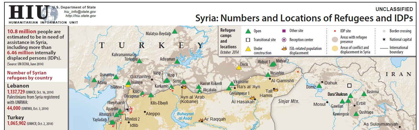
The second article, State Department: Mapping the humanitarian crisis in Syria, is a shorter piece that focuses solely on the HIU and its work in mapping the Syria humanitarian crisis. Having worked closely on Syria for two years, I can say we put a tremendous amount of effort into building comprehensive refugee datasets, verifying data from news reports, NGO reports, and commercial satellite imagery. Additionally we built inter-agency compatible data schema that leveraged geographic locations and P-Codes for information integration (P-Code dataset, P-Code Viewer). And to visualize it all, we built custom web mapping applications with tools to interactively explore all of the data across time and space. A significant portion of the HIU work on Syria (and now Iraq) is available on the HIU Middle East Products page, additionally, the data used for the Refugee and Internally Displaced Peoples layers are available for download on the HIU Data page.
It is clear the appreciation and value for geographical data, analysis, and visualization are on the rise; FCW lists the the Why Maps Matter article as the 3rd most popular of 2014. Fully recognizing the value of geography requires that the notion of maps as “pieces of paper” must be replaced with an appreciation and use of geographic data and spatial analysis as a tool of policy formation. This change is happening, albeit slower than I’d like, but its adoption will result in better, more agile policy, and benefit the government and citizens alike.

RT @disruptivegeo: New DisruptiveGeo blog post, Summary of “Why Maps Matter” articles – http://t.co/w7zJNRgkVa // cc @frank_konkel
RT @disruptivegeo: New DisruptiveGeo blog post, Summary of “Why Maps Matter” articles – http://t.co/w7zJNRgkVa // cc @frank_konkel
Why Maps Matter at http://t.co/Y7IKW3rRIW
Why Maps Matter || http://t.co/5j6qyPqHrJ
New DisruptiveGeo blog post, Summary of “Why Maps Matter” articles – http://t.co/w7zJNRgkVa